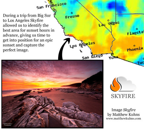
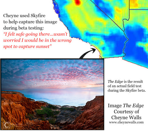
In the world of outdoor photography and sunset viewing, finding the perfect light has always been a matter of chance. Until Skyfire. Now you can map out exactly when and where the epic light will occur so you don’t have to worry about missing out on that award winning shot ever again.
Matthew Kuhns, an award winning California-based landscape photographer, Aerospace Engineer and long-time friend of pictureline, is the brain behind Skyfire, a genius program that predicts the best golden hour lighting for your photography.
The idea for Skyfire took shape when Matt was exploring the Southwest in search of that perfect photograph, and driving hundreds of miles to chase that pristine light on chance wasn’t working for him. So, with his Aerospace engineering background, Matt approached the problem scientifically; a complex algorithm based on satellite images, nationwide weather observations, and mastery of the elements that make up a great sunrise and sunset.
Development of the code started in early 2014, but Matthew began putting together the important equations back in 2011. The original goal was to develop a method for predicting how nice the sunrise was going to be the night before, allowing photographers to plan their shoot accordingly to achieve the very best images (and, more importantly, to sleep in a few more hours if the sunrise was no good).
The program sounds pretty amazing, right? So you’re probably asking yourself, "Does it work, though?" Short answer, as Matthew would put it, is YES! "Working with weather experts and using my skill at generating algorithms to break down and predict behavior in complex systems, an algorithm has been developed to show when conditions are best for great light," Matthew says, "Our beta testing showed 94% accuracy in coast to coast predictions utilizing a statistically significant sample size. And being the perfectionists we are, the algorithm is continually being improved to allow for predictions reaching further out as well as increased accuracy around areas with complex weather patterns."
It all sounds really complicated and intelligent, so chances are it works, but Skyfire still provides a 30-day free trial as well as a 60-day money back guarantee, they are so confidant you’ll love the program.
 Beta Testing Results © Skyfire App
 Beta Testing Results © Skyfire App
 Beta Testing Results © Skyfire App
When it comes to actually determining where the best light will be, the program is really straightforward. Simply look at the map of the United States, and evaluate the color-coded graph as to where you should high tail it for the best lighting. Skyfire uses both an interactive and static display to show you where the best light will be by using Google Maps. Need to know the exact location for the sunset? Use the detailed map of roads and terrain! Don’t expect to have cell service much longer? That’s okay too; just use the static map to save the location of where you need to go!
 The Skyfire map displayed using Google Maps © Skyfire App
 State lines, cities and roads easily visible to guide you to the best light © Skyfire App
 Regional resolution and terrain overlay © Skyfire App
 Zoom in all the way to street level. Base satellite data uses 2 km resolution © Skyfire App
Galen Rowell, professional landscape, wildlife/wilderness photographer said, "all photographs are made from three parts; skill, equipment, and environment." Skyfire lets you master the one element that has always been impossible to predict; the environment.
Predictions for this evening show that some of the best areas for lighting and clouds nearby are the Boise National Forest in Idaho, with several other spotting in Nevada, Colorado and Wyoming. So if you're eager to get some images of a spectacular sunset, and ideal lighting, you better pack up the car and head out now! Safe travels!
 Sunset predictions for Novemeber 11, 2014 © Skyfire App
 Sunset predictions for November 11, 2014 © Skyfire App
The app it will be available for mobile devices via Kickstarter in 2015. For more questions regarding the Skyfire program, visit their website and FAQ page.


